


MANILA, Dec. 26 (PNA) — Typhoon “Nina” (international name Nock-ten) has weakened but stormy weather is expected to continue in the southern Tagalog and Bicol regions, state weather agency Philippine Atmospheric, Geophysical and Astronomical Services Administration (PAGASA) said Monday morning.
In its 8 a.m. bulletin, PAGASA said the eye of “Nina” was last spotted 60 kilometers south of Tayabas, Quezon province.
It has a maximum sustained winds of up to 140 kph near the center, and gustiness of up to 230 kph. It is forecast to move west northwest at 20 kph.
“Nina” is expected to leave the Philippine Area of Responsibility on Wednesday (Dec. 28).
The state weather bureau has advised that sea travel is risky over the seaboards of Luzon and storm surge height of up to 2.5 meters is possible over the coastal areas of Camarines Sur and southern Quezon, PAGASA noted.
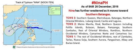
Areas under tropical cyclone warning signal (TCWS) no. 3 are Southern Quezon, Marinduque, Batangas, northern Oriental Mindoro, Lubang Island, Cavite and Laguna.
Metro Manila, Rizal, northern Quezon including Polillo Islands, Bulacan, Bataan, Pampanga, southern Zambales, rest of Oriental Mindoro, Romblon, northern Occidental Mindoro, Camarines Norte, and Camarines Sur are under TCWS no. 2.
The rest of Occidental Mindoro, rest of Zambales, Tarlac, Nueva Ecija, southern Aurora, Pangasinan, Albay, and Burias Island are under TCWS no. 1. (PNA)
JMC/MCCA


