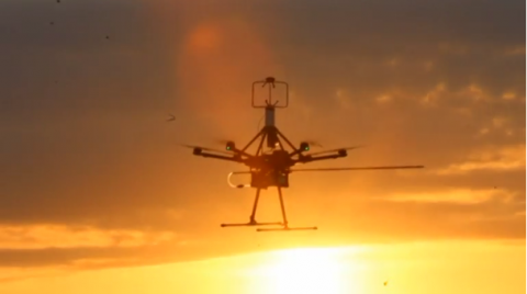
EL RENO, Oklahoma (Reuters) — Scientists based in America’s infamous “tornado alley” are using drone technology to better understand how tornadoes and other severe weather phenomena develop.
They hope new data could lead to better early warning systems that would increase the current advanced warning time of about 14 minutes to more than an hour.
Speaking to Reuters at the Paris Air Show, Dr. Kelvin Droegemeier, Oklahoma’s secretary of science and technology, said this new tool for sampling the atmosphere could be a game-changer for forecasting.
“With advanced numerical models and data from drones we think we might be able to get the warning lead time up to well over an hour,” he said.
“We would actually warn based on a computer forecast on a storm that may not even exist at the moment.”
In 2015, a $6-million grant from National Science Foundation was awarded to Oklahoma State University and the universities of Oklahoma, Nebraska and Kentucky to develop the unmanned aircraft system (UAS) for the study of atmospheric physics.
Its goal is to build small, affordable drones for use by government and university scientists, as well as private companies, to improve weather forecasting.
Researchers, including teams from the National Oceanic and Atmospheric Administration’s (NOAA) National Severe Storms Laboratory, located in Norman, Oklahoma, are currently testing several drone designs, including quadcopters and fixed wing aircraft.
Most of the research is being conducted using off-the-shelf drones with sensing equipment bolted on.
But they’re also designing their own UAVs that can cope better with gusty and wet pre-storm conditions.
“We want to take it out in the pre-thunder storm environment, prior to storms forming, to capture the antecedent conditions before the storm forms,” he said.
“That will give us an opportunity to understand better how storms form and improve the forecasting of when and especially where thunderstorms form.”
Currently meteorologists primarily rely on ground-based instruments and satellites. But Droegemeier, himself a meteorologist, said it’s the important region in the lower atmosphere that has proved most elusive using traditional tools.
“We observe very well at the ground, we observe pretty well at high altitude; satellites look down from above. But it’s that first 2, 3 kilometers of the atmosphere above the ground level that are most important. This is where drones really come in to play,” he said.
Tornadoes, rapidly spinning columns of air usually spawned by rotating thunderstorms, can cause extensive loss of life and property damage like the May 2011 twister in Joplin, Missouri, that killed about 160 people and wrecked thousands of homes.
The state of Oklahoma sits in the middle of “tornado alley” – the region stretching from Texas to Iowa that accounts for roughly a fourth of all US tornadoes.
Its location has made the state a global center for meteorology.
Data captured from a network of satellites around the globe is sent to NOAA’s National Severe Storms lab in Norman where it is analyzed and then shared with meteorologists around the world to help forecast weather.


