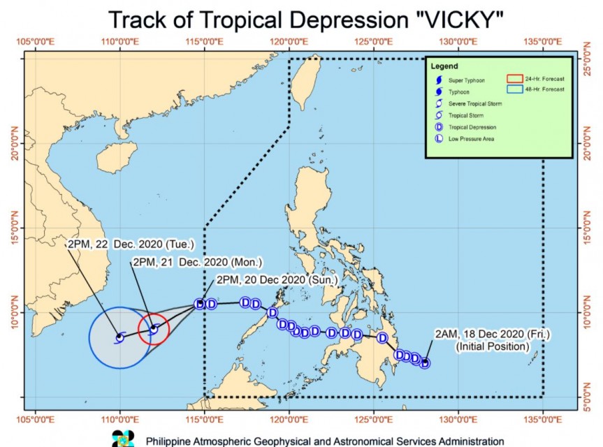
(Eagle News) — Tropical Depression “Vicky” left the Philippine Area of Responsibility (PAR) at 2 p.m. today, Sunday, Dec. 20, according to the country’s weather bureau, PAGASA.
As of 4 p.m. today, the center of Tropical Depression “VICKY” was estimated based on all available data at 70 km Southeast of Kalayaan, Palawan, which is already outside PAR.
“Vicky” is forecast to move generally southwestward as it comes under the full influence of the surge of the Northeast Monsoon. It is forecast to intensity into a tropical storm in the next 12 hours.
“However, it is less likely to reach severe tropical storm category throughout the forecast period due to marginally favorable conditions,” PAGASA said in its 5 p.m. bulletin.
It said that the “combined effects of the Tail-End of a Frontal System (Shear Line) and Tropical Depression VICKY” will bring until tonight “moderate to heavy with at times intense rains over mainland Cagayan Valley, Apayao, Kalinga, Mountain Province, Ifugao, Aurora, Quezon, Bicol Region, northern portion of Palawan including Calamian Islands, and Kalayaan Islands.”
It will also bring light to moderate with at times heavy rains over Babuyan Islands and the rest of Cordillera Administrative Region.
Tomorrow, Monday, Dec. 21, moderate to heavy rains are expected over Babuyan Islands, mainland Cagayan Valley, Aurora, Apayao, Kalinga, Mountain Province, Ifugao, and the northern portion of Quezon. Light to moderate with at times heavy rains over Batanes, Kalayaan Islands, and the rest of Cordillera Administrative Region.
“In the next 24 hours, the combined effects of the surge of the Northeast Monsoon and the tropical depression will bring rough to high seas (2.8 to 6.0 m) over the entire seaboards of Northern Luzon, rough to very rough seas (2.8 to 4.5 m) over the seaboard of Zambales, the western seaboard of Bataan, the seaboard of Lubang Island, the western seaboard of Palawan including Calamian and Kalayaan Islands, the seaboard of Aurora, the eastern seaboard of Quezon including Polillo Islands, the northern seaboard of Camarines Norte, the northern and eastern seaboards of Catanduanes, the eastern seaboard of Albay including Rapu-Rapu Islands, the eastern seaboard of Sorsogon,” PAGASA said.
“Moderate to rough seas (2.0 to 3.5 m) will also be experienced over the western seaboard of Batangas, the western seaboard of Occidental Mindoro, eastern seaboard of Eastern Samar including Homonhon Island, the eastern seaboard of Dinagat Islands, the eastern seaboard of Surigao del Norte including Siargao and Bucas Grande Islands, and the eastern seaboard of Surigao del Sur,” it added.
PAGASA also advised mariners of small seacrafts to take precautionary measures when venturing out to sea, and for “inexperienced mariners” to “avoid navigating in these conditions.”
(Eagle News Service)


