Gusty conditions forecast over extreme Northern Luzon but no tropical cyclone wind signal forecast to be hoisted

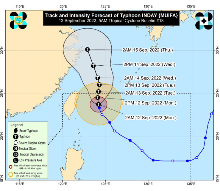
(Eagle News) — Typhoon “Inday” has slightly weakened as it approaches the Yaeyama Islands of Southern Japan.
According to the Philippine Atmospheric Geophysical and Astronomical Services Administration (PAGASA), the typhoon, however, is unlikely to directly bring heavy rains in the country throughout the forecast period.
As of PAGASA’s 5 a.m. weather bulletin, the The center of the eye of Typhoon INDAY was estimated based on all available data at 425 km Northeast of Itbayat, Batanes (23.9 °N, 124.2 °E )
It has maximum sustained winds of 155 kilometers per hour near the center and gustiness of up to 190 km/h, and is moving north northwestward at 10 km/h.
PAGASA said gusty conditions reaching strong to gale-force strength may be experienced over extreme Northern Luzon tomorrow through Wednesday due to the channeling of the typhoon circulation in the Luzon Strait.
In the next 24 hours, “Inday” may also bring moderate to rough seas over the eastern seaboard and the remaining northern seaboard of Northern Luzon.
According to the weather bureau, “Inday” will move slowly northward, either pass close or make landfall in the vicinity of Yaeyama Islands this morning or afternoon.
It is expected to exit the Philippine Area of Responsibility (PAR) tonight or tomorrow early morning.
“Inday” is forecast to gradually weaken throughout the forecast period due to the cooler waters over sea east of Taiwan (resulting from upwelling brought on by the slow movement of the typhoon) and East China Sea, and increasing vertical wind shear along its projected path, PAGASA said.
“The hoisting of Tropical Cyclone Wind Signals is unlikely throughout the forecast period,” it added.
(Eagle News Service)


