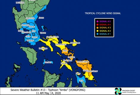
(Eagle News) — “Ambo” has maintained its strength as it approaches the Eastern and Northern Samar area on Thursday, May 14.
The Philippine Atmospheric Geophysical and Astronomical Services Administration said the eye of Typhoon “Ambo” was located 140 km east southeast of Catarman, Northern Samar as of 10 a.m., and is expected to make landfall over Northern Samar or the northern portion of Eastern Samar between 12 p.m. and 2 p.m. before heading towards Sorsogon later tonight.
PAGASA said violent winds and heavy to torrential rains of the eyewall region will begin affecting Northern Samar and the northern portions of Samar and Eastern Samar within 12 hours, as “Ambo” packs maximum sustained winds of up to 150 kph near the center and gustiness of up to 190 kph.
Sorsogon, Albay, and Ticao Island Northern Samar, the northern portion of Eastern Samar (Jipapad, Arteche, Maslog, Dolores, Oras, San Policarpio, Can-avid, Taft, Sulat, San Julian, Borongan City, Maydolong), and the northern portion of Samar (Calbayog City, Sta. Margarita, Gandara, Pagsanghan, San Jorge, Matuguinao, San Jose de Buan, Catbalogan, Jiabong, Motiong, Paranas, Tarangnan, San Sebastian, Hinabangan) remain under Signal No. 3.
PAGASA said areas under Signal No. 3 will experience “strong to destructive typhoon-force winds during the passage of the typhoon.”
Signal No. 2 is hoisted over the southern portion of Quezon (Pagbilao, Atimonan, Padre Burgos, Plaridel, Agdangan, Unisan, Gumaca, Pitogo, Macalelon, Lopez, Caluag, General Luna, Catanauan, Perez, Alabat, Quezon, Tagkawayan, Guinayangan, Buenavista, San Narciso, Mulanay, San Andres, San Francisco), Camarines Norte, Camarines Sur, Catanduanes, Burias Island, mainland Masbate, and Marinduque
Biliran, the rest of Samar, and the rest of Eastern Samar, which means they will experience “strong to damaging gale/storm-force winds.”
Aurora, the southern portion of Nueva Ecija (General Mamerto Natividad, Palayan City, Cabanatuan, Santa Rosa, Jaen, San Isidro, San Antonio, Cabiao, Bongabon, Gabaldon, General Tinio, Laur, San Leonardo, Peñaranda, Gapan City), Bulacan, Metro Manila, Cavite, Laguna, Batangas, Rizal, the rest of Quezon, Romblon, Bataan, and Pampanga The northern portion of Leyte (Calubian, San Isidro, Tabango, Villaba, Leyte, Kananga, Capoocan, Carigara, Barugo, San Miguel, Babatngon, Tunga, Jaro, Alangalang, Sta. Fe, Tacloban City, Palo, Pastrana, Dagami, Tabontabon, Tanauan, Tolosa, Ormoc City, Matag-ob, Palompon, Merida, Isabel, Albuera, Burauen, Julita, Dulag) are still under Signal No. 1.
Areas under this storm signal will experience “strong to near gale-force winds during the passage of the typhoon.”
Today, heavy to intense with at times torrential rains over Samar Provinces, Masbate, Sorsogon, and Catanduanes, while moderate to heavy with at times intense rains are expected over Albay, Camarines Sur, and the rest of Eastern Visayas.
Heavy to intense with at times torrential rains are forecast over Bicol Region tomorrow.
Moderate to heavy with at times intense rains are also expected over Northern Samar, Quezon, Aurora, Marinduque, and Romblon tomorrow, PAGASA said.
Within 24 hours, a storm surge of 2.0 to 4.0 meters may be experienced over the coastal areas of Northern Samar, Eastern Samar (east coast), Samar (west coast), Sorsogon, Albay, Catanduanes, Camarines Sur, Camarines Norte, Quezon, and Aurora.
PAGASA said along with large swells, this storm surge may cause life-threatening coastal inundation.
Sea travel is risky for all types of seacrafts over the seaboards of areas under storm signals.


