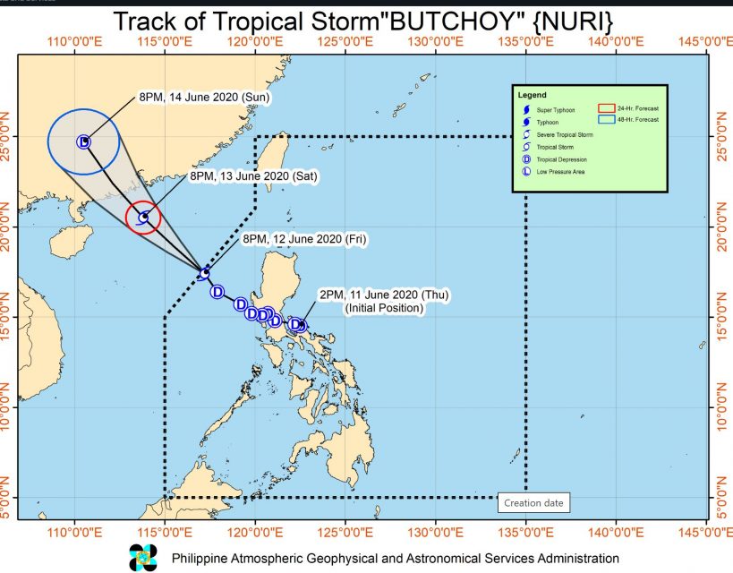
(Eagle News) — “BUTCHOY” intensified into a tropical storm as it exited the Philippine Area of Responsibility (PAR), according to PAGASA’s weather bulletin issued on Friday, June 12 at 11 p.m.
But even though “Butchoy” (international name Nuri) is now outside the country, “occasional gusts associated with the Southwest Monsoon may still be experienced over most of Northern and Central Luzon and the western section of Southern Luzon and Visayas.”
At 10:00 PM Friday, the center of Tropical Storm “BUTCHOY” was estimated based on all available data at 415 km West Northwest of Dagupan City, Pangasinan or 380 km West of Sinait, Ilocos Sur (OUTSIDE PAR (17.6 °N, 116.8 °E )
It was amving Northwestward at 20 km/h, with maximum sustained winds of 65 km/h near the center and gustiness of up to 80 km/h
PAGASA said that until Saturday morning, June 13, there will be “light to moderate rains with at times heavy rains over Zambales, Bataan, Pangasinan, the northern portion of Palawan including Calamian and Cuyo Islands, and Occidental Mindoro.”
“Residents in these areas are advised to take appropriate measures, coordinate with local disaster risk and management offices, and continue monitoring for updates, especially the local rainfall or thunderstorm advisories and heavy rainfall warnings from PAGASA Regional Services Divisions (PRSD),” PAGASA said in the bulletin.
“Flooding and rain-induced landslides may occur in highly to very highly susceptible areas,” it said.
PAGASA also warned that in the next 24 hours, moderate to very rough seas (1.5 to 4.0 m) will be experienced over the seaboards of Northern and Central Luzon especially over the seaboards of Ilocos Region, Zambales and Bataan. This is due to BUTCHOY and the Southwest Monsoon.
Sea travel is risky especially for those using small seacrafts.
(Eagle News Service)


