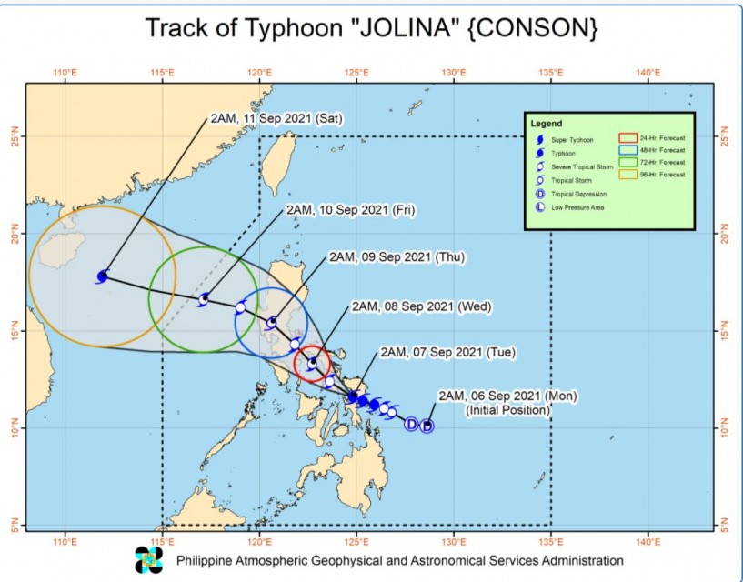
As of 4 a.m., typhoon Jolina has already made 2 landfalls in Samar

(Eagle News) – Tropical storm “Jolina” (international name Conson) is now a typhoon with maximum sustained winds of 120 kilometers per hour and gusts of up to 180 km/h, with PAGASA declaring parts of Masbate under signal number 3.
PAGASA said that typhoon “Jolina” has already “emerged over the Samar Sea and is now crossing the island municipalities of Samar province.”
It has so far made two landfalls: in Daram, Samar (2:00 AM) and Sto Niño, Samar (3:40 AM)
As of 4 a.m. the center of the eye of typhoon “JOLINA” was estimated based on all available data including those from Guiuan Doppler Weather Radar over the coastal waters of Sto. Niño, Samar (11.9°N, 124.4°E).
Strong winds or higher extend outwards up to 180 km from the center
-Areas under Tropical Cyclone Wind Signal-
Those placed under tropical cyclone wind signal no. 3 are the eastern portion of Masbate (Pio V. Corpuz, Palanas, Cataingan, Placer, Dimasalang, Uson, Cawayan, Esperanza, Mobo) including Ticao Island
The areas under signal no. 2 are the following:
Albay, Sorsogon, the rest of Masbate including Burias Island, the western and southern portions of Camarines Sur (Del Gallego, Lupi, Ragay, Libmanan, Sipocot, Cabusao, Pasacao, Pamplona, Gainza, Camaligan, Canaman, Magarao, Bombon, Naga City, Pili, Ocampo, Iriga City, Sagñay, Buhi, Milaor, San Fernando, Minalabac, Bula, Nabua, Baao, Balatan, Bato, Calabanga), the eastern portion of Marinduque (Torrijos, Santa Cruz), southeastern portion of Quezon (Tagkawayan, Guinayangan, Buenavista, Mulanay, San Narciso, San Francisco, San Andres, Catanauan, Calauag, General Luna, Lopez, Macalelon), and the eastern portion of Romblon (San Fernando, Magdiwang, Cajidiocan, Romblon, Banton, Corcuera)
The areas under signal no. 1 are the following:
Catanduanes, the rest of Camarines Sur, Camarines Norte, the rest of Quezon including Polillo Islands, Laguna, the eastern portion of Batangas (Santo Tomas, Lipa City, San Jose, Batangas City, Ibaan, Rosario, Padre Garcia, San Juan, Taysan, Lobo, City of Tanauan, Malvar, Balete, Mataasnakahoy, Cuenca, San Pascual), the rest of Marinduque, the rest of Romblon, the northern and central portions of Oriental Mindoro (City of Calapan, Naujan, Victoria, Socorro, Pola, Pinamalayan, Gloria, Bansud, Bongabong, Roxas, Baco, San Teodoro, Puerto Galera)
PAGASA said that in the next 24 hours, “JOLINA” may bring heavy to intense with at times torrential rains Eastern Visayas, Sorsogon, and Masbate. Moderate to heavy with at times intense rains are also likely over the southern portion of Quezon, Romblon, Marinduque and the rest of Bicol Region and Visayas.
“Under these conditions, scattered to widespread flooding (including flash floods) and rain-induced landslides are possible especially in areas that are highly or very highly susceptible to these hazard as identified in hazard maps,” it said.
It said “destructive typhoon-force winds are likely to occur within any of the areas where Tropical Cyclone Wind Signal #3 is in effect,” while damaging gale-force to storm-force winds are likely to occur within any of the areas where TCWS #2 is in effect.
-Next landfall in the vicinity of Masbate-
Within the next 12 hours, the typhoon is forecast to move over the Samar Sea and pass over or close to the island municipalities of Samar and the northern coast of Biliran before making landfall in the vicinity of Masbate (mainland or Ticao Island), PAGASA said in its 5 a.m. bulletin.
During this period, typhoon Jolina may weaken into a severe tropical storm. Beyond the next 12 hours, “Jolina” will move northwestward towards Burias Island and the vicinity of Ragay Gulf before making another landfall in the vicinity of southeastern Quezon tonight or tomorrow early morning. Further weakening is likely during this period, PAGASA explained.
By tomorrow afternoon, “Jolina” will briefly emerge over Lamon Bay before making landfall in the vicinity of northern Quezon. Throughout the remainder of tomorrow and into tomorrow morning, the tropical cyclone is forecast to cross Central Luzon (roughly to the east and north of Metro Manila).
Frictional effects during its traverse of Luzon landmass will weaken “JOLINA” down to tropical storm category.
“Jolina” is forecast to emerge over the West Philippine Sea before noon on Thursday. Re-intensification is forecast to occur beginning on Thursday afternoon as the tropical cyclone moves west northwestward over the West Philippine Sea towards the southern China-northern Vietnam area, PAGASA added.
(Eagle News Service)


