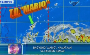
MANILA, Sept. 17 (PNA) -– The low pressure area located southeast of Luzon has intensified into tropical depression “Mario,” the third for this month and 13th tropical cyclone to enter the country this year, the Philippine Atmospheric, Geophysical and Astronomical Services Administration (PAGASA) said on Wednesday.
PAGASA weather forecaster Connie Dadivas said that as of 4:00 p.m., tropical depression “Mario” was located at 740 km east of Borongan, Eastern Samar (12.2°N, 132.8°E) packed with maximum winds of 45 kph. It is forecast to move west northwest at 24 kph.
Dadivas said that since “Mario” is still in the sea, the tropical depression is expected to intensify into a tropical storm category.
Maintaining its speed and movement, she said tropical depression “Mario” is not expected to make landfall and no public storm warning signal has been raised since it is still not directly affecting the country.
However, Dadivas said the outer rain cloud bands of the tropical depression will induce light to moderate rainshowers over Visayas, Zamboanga Peninsula, Northern Mindanao, Caraga and Davao Region.
She added the rest of the country, including Metro Manila, will continue to experience fair weather with partly cloudy to cloudy skies with isolated rainshowers or thunderstorms.
In the coming days, Dadivas said TD “Mario” is expected to enhance the southwest monsoon that will bring rains over Southern Luzon.
PAGASA said tropical depression Mario is forecast to be at 340 km east of Virac, Catanduanes by Thursday afternoon.
By Friday afternoon, it is expected to be at 360 km east of Aparri, Cagayan and by Saturday afternoon at 660 km northeast of Basco, Batanes.
The estimated rainfall amount is from 7.5 – 15 mm per hour (moderate to heavy) within the 300-km diameter of the tropical depression.
It added that fisherfolks and those with small seacrafts are advised not to venture out over the eastern seaboard of Visayas while sea travel is risky over the western seaboard of Northern Luzon. (courtesy PNA)


