
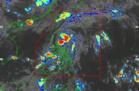
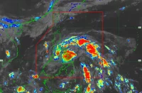
(Eagle News) — The Philippine Atmospheric Geophysical and Astronomical Services Administration is monitoring a tropical depression outside the Philippine Area of Responsibility.
PAGASA said the weather disturbance was located 1080 kilometers east of Mindanao as of 3 a.m.
It is packing maximum sustained winds of 45 kilometers per hour and gustiness of up to 55 kph, and is moving westward.
Meanwhile, Visayas, Caraga, Northern Mindanao, SOCCSKSARGEN and Zamboanga Peninsula will have cloudy skies with scattered rainshowers and thunderstorms due to the tail-end of a frontal system (shear line) affecting the eastern section of Visayas and Mindanao.
Flashfloods or landslides due to moderate with at times heavy rains are possible.
Cagayan Valley, Bicol Region, Aurora, and Quezon, on the other hand, will have cloudy skies with light rains, this time due to the northeast monsoon affecting Luzon.
Metro Manila and the rest of Luzon will have partly cloudy to cloudy skies with isolated light rains.
The rest of the country will have partly cloudy to cloudy skies with isolated rainshowers or thunderstorms.
According to PAGASA, the northern and eastern section of the country will have moderate to strong winds and moderate coastal waters.
The rest of Luzon, Visayas, and Mindanao, on the other hand, will have light to moderate winds and slight to moderate coastal waters.


