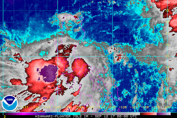
(Eagle News) — Tropical Depression “Maring” slightly intensified as it moved in a more westward direction and is expected to make landfall over Mauban, Quezon this morning.
In its 8 a.m. press conference, the Philippine Atmospheric, Geophysical and Astronomical Services Administration said “Maring,” which is now 35 km south-southeast of Infanta, Quezon, now packed sustained maximum winds of 60 to kph.
Signal No. 1 is hoisted over Cavite, Bicol, Metro Manila, Camarines provinces, Rizal, Quezon province, Bulacan, Pampanga, Quirino, Nueva Ecija, Tarlac, Zambales, Bataan, Pangasinan, Aurora, Quirino, Laguna, Nueva Vizcaya, La Union and Benguet.
As of 8 a.m., the orange rainfall warning is up in Cavite, Batangas and Pampanga, which means residents should prepare for the possibility of flooding as 15 to 30 millimeters/hour of rain are expected in those areas.
Metro Manila, Bataan, Nueva Ecija, Pampanga, Bulacan, Batangas and Quezon are under a yellow rainfall warning, which means they can expect 7.5 to 15 mm/hour of rain.
“Maring” is expected to exit Luzon early Wednesday.
On Wednesday morning, it is expected in the western section of Zambales.
According to Pagasa, “Maring” –which is moving slowly because of its interaction with Typhoon “Lanie”—is expected to leave the Philippine Area of Responsibility on Thursday.


